Yolo County

To use the map above, click on any point. You’ll find the name and a brief description with a link to additional information. Alternatively, you can click on the square with an arrow in the upper left hand corner of the map to open a complete list of all the locations on this map. The map is easier to use if you enlarge it by clicking on the partial square in the top right portion of the map.

Fees and directions may have changed. If you have recommended changes for a location, please email them to the Web Committee.


Bridgeway Island Pond

This year-round pond in West Sacramento near the eastern edge of the Yolo Causeway was designed to hold storm water for flood control purposes. The pond usually carries deep water although filled only by rain events and nearby homeowner watering run off. There is no better place in California to see Blue-winged Teal.

Almost 200 species have been reported here including a male Garganey in the winter of 2019 which was seen by many birders. Look and listen for Green Herons, Common Yellowthroats, Marsh Wrens in the marshy edges, and Pied-billed Grebes, Double-crested Cormorants, and American White Pelicans working the pond. Forster’s Terns and several gull species can often be found overhead as well as White-tailed Kites and Red-tailed Hawks in the nearby uplands. Bald Eagles are seen in winter. A large central island serves a variety of resident species year-round with additional large numbers of waterfowl and shorebirds from fall to spring. Unusually large numbers of Blue-winged Teal show up each winter along with Gadwall and both Cinnamon and Green-winged Teal. There are also Black-necked Stilts and Avocets most of the year. Even during the hot summer, a surprising number of birds can be found here including resident Soras and Virginia Rails.

Blue-winged Teal, Image by Daniel Brown

Blue-winged Teal, Image by Daniel Lee Brown

Birding the Site: From the Pender Island Street cul-de-sac, walk to the pond and scan the water and large island. Then head west through the gate and follow the trail around the west and north edges of the pond. It is also possible to explore the surrounding uplands and the Deep-Water Ship Channel via the levee separating West Sacramento from the Yolo Causeway. A scope is invaluable. eBird Sightings

Directions: From downtown Sacramento, take Hwy. 50 west, cross over the Sacramento River and take the Jefferson Boulevard exit. Turn left onto Jefferson and turn right on Lake Washington Boulevard. Follow Lake Washington Boulevard and then turn left onto Southport Parkway. At 2.8 miles, turn right on Oakland Bay Drive, make an immediate right onto Bowen Island Street, left on Solomon Island Road and right on Pender Island Street. Park at the end of the cul-de-sac.

 Maureen Geiger


Yolo Bypass Wildlife Area (aka the Vic Fazio Wildlife Area)

American Bittern, Image by Craig Swolgaard

American Bittern, Image by Craig Swolgaard

This Global-Priority Level Important Bird Area (IBA) now contains more than 25,000 acres and is just minutes from downtown Sacramento. Both seasonal and permanent wetlands are present as well as riparian woodland and valley grassland, providing habitat for a large variety of birds. Seasonal flooding provides key habitat for countless waterfowl migrating along the Pacific Flyway, one of four major migratory routes in the United States.

The wildlife area is open to the public when the bypass is not flooded. General hours are sunrise to sunset, with the wildlife area closed on Christmas Day. The entrance gate may be closed on holidays if staff are unavailable. During hunting season (September-February), auto and pedestrian access is limited to the auto tour loop. Additional areas are open to autos and pedestrians the rest of the year. You may park along the gravel roads as well as in designated parking areas. A number of foot trails are available from various parking lots. The headquarters, which features exhibits of local birds, is located on Chiles Road (parallel to and south of Interstate 80) west of the entrance to the wildlife area.

Birding the site: Shorebirds and waterfowl are often present in large numbers from fall through spring, depending on water levels. Occasional Tricolored Blackbirds and Yellow-headed Blackbirds are seen from spring through fall. Raptors abound, including nesting Swainson’s Hawks and Northern Harriers. American Bitterns, Soras, and Virginia Rails can sometimes be found. River otters are present in the canals and ponds year-round.

Cinnamon Teal are common, and Ruddy Ducks and Gadwalls are present year-round. Green-winged Teal and occasional Blue-winged Teal can be found except during mid-summer months. When the bypass is flooded, diving ducks can be present in large numbers. At times, thousands of Canvasbacks, Ring-necked Ducks, and Lesser Scaup can be seen; when the causeway is flooded, these birds can be scoped from the levee at the entrance gate. This is the most reliable site in the Sacramento area to find Greater Scaup. American White Pelicans utilize the deeper ponds for feeding. Large flocks of Greater Yellowlegs often contain Lesser Yellowlegs. These and large dowitcher flocks may contain an occasional Ruff, and shorebird concentrations can attract a Peregrine Falcon or Merlin. Rarities are possible, with Glossy Ibis, Curlew Sandpiper, Sharp-tailed Sandpiper, and American Tree Sparrow seen in past years.

In summer, southern migration results in large numbers of swallows, including Tree, Cliff, Barn, and occasional Bank. Horned Larks breed here and Savannah Sparrows were noted as breeding in 2016. Common Yellowthroats and Marsh Wrens are numerous. White-faced Ibis, occasionally numbering in the thousands, may be found flying into and over the area to roost at night and to feed in the surrounding fields during the day. eBird Sightings

You can read more about the accessible features of this locations on our Accessible Birding page.

Directions: From the intersection of Interstate 5 and Hwy 50 in Sacramento, drive west on Hwy 50 for 3.4 miles to where Interstate 80 merges with Hwy 50. Continue west on Interstate 80 for about 4.0 miles across the Yolo Causeway and exit at East Chiles Road/Road 32A (exit 78). Turn right at the stop sign and follow the road as it curves to the right and heads south, passing under the freeway. Shortly after, turn left, drive up onto the levee, then drop down into the wildlife area. The auto loop is posted along its route.

See updated maps & information on the Yolo Basin Foundation website.

Maureen Geiger


Wood Duck Ponds and Babel Slough

Wood Duck, Image by Daniel Brown

Wood Duck, Image by Daniel Lee Brown

Notice: Please use caution if parking and walking along Babel Slough. The Yolo County Sheriff’s Department issued parking tickets on 3/16/24 to birders parked on the South River Road near Babel Slough.

These two sites just west of the Sacramento River make for an excellent morning of birding in the spring and fall.

Birding the site: Coming from Sacramento, you will reach the Wood Duck Ponds first. Park on the side of Chicory Loop. Informal trails wind through the riparian tangles around the ponds. Use caution exploring these trails as there have been homeless encampments and trash dumping here. Alternatively, the ponds and woods can be scanned from the side of the road with binoculars or a spotting scope. Dozens of Wood Duck inhabit the ponds year-round. When there is a good pulse of migrants, the woods can be hopping with warblers and other songbirds.

Babel Sough Road heads west from South River Road, 5.6 miles south of the Wood Duck Ponds. You can park along the east side (river side) of South River Road, just north of Babel Slough Road. The narrow strip of trees on either side of the road holds a disproportionately large number of birds, and the viewing conditions are usually very good, since the strip is narrow enough to keep the birds close to you. This area is excellent for Empidonax flycatchers and has produced rarities including Chestnut-sided Warbler, Ovenbird, and Rose-breasted Grosbeak. There is simply no better place to be during migration. Walk the road, looking and listening for birds, but also beware of the infrequent cars. eBird Sightings - Wood Duck Ponds, Babel Slough

It is best to park on South River Road and walk west along Babel Slough Road. Local landowners have been hostile to people parking along Babel Slough Road, probably because they are wary of people dumping trash there. The road runs for over three miles between Jefferson Boulevard and South River Road, but most of the birder coverage has been in the first half-mile west from South River Road. The gravel shoulder on the east side of South River Road just prior to Babel Slough Road is an excellent area to park.

Notice: Please use caution if parking and walking along Babel Slough. The Yolo County Sheriff’s Department issued parking tickets on 3/16/24 to birders parked on the South River Road near Babel Slough.

Directions: From Sacramento, at Interstate 5 and Highway 50, head west on Highway 50. Cross the Sacramento River and exit at Jefferson Boulevard (exit 3) in West Sacramento. After winding under the freeway, head south (left turn) on Jefferson Boulevard for 2.3 miles. Turn left on Linden Road and go 1.2 miles. Turn right on to Village Parkway. Go 0.3 miles and turn left on to Chicory Loop. Drive easterly towards the river for 0.2 mi, and at the top of the levee, turn right to follow the road formerly known as South River Road, and drive south 0.3 mi. Park on the dirt shoulder above Wood Duck Ponds.

To get to Babel Slough Road from here, continue 0.34 miles on Chicory Loop (formerly known as S. River Road), passing a marina, then turn right to come down off the levee and continue on Chicory Loop for another 0.2 mi to Village Parkway. Turn left on Village Parkway and go 1.9 miles to Gregory Road. Turn left and drive 0.3 mi southeast on  Gregory Road (As the road curves right, it becomes South River Road.) Drive 2.75 miles to Babel Slough Road.

To go directly to Babel Slough Road from Sacramento, follow the directions to the Jefferson Boulevard exit (above), then head south for 3.6 miles on Jefferson Boulevard, and turn left at Gregory Avenue. After 1.2 miles, bear right on South River Road, and drive 2.75 mi to Babel Sough Road. Park in the gravel shoulder on the east side of South River Road just north of Babel Slough Road.


Davis City Limits

Chestnut-backed Chickadee, Image by Daniel Brown

Chestnut-backed Chickadee, Image by Daniel Lee Brown

Davis provides several excellent sites for birders. Davis residents can reach them on foot, by bike, or very short drives. A dedicated corps of Yolo Audubon birders covers these sites very well, and rarities are often reported. A small sample of the available birding opportunities follows.
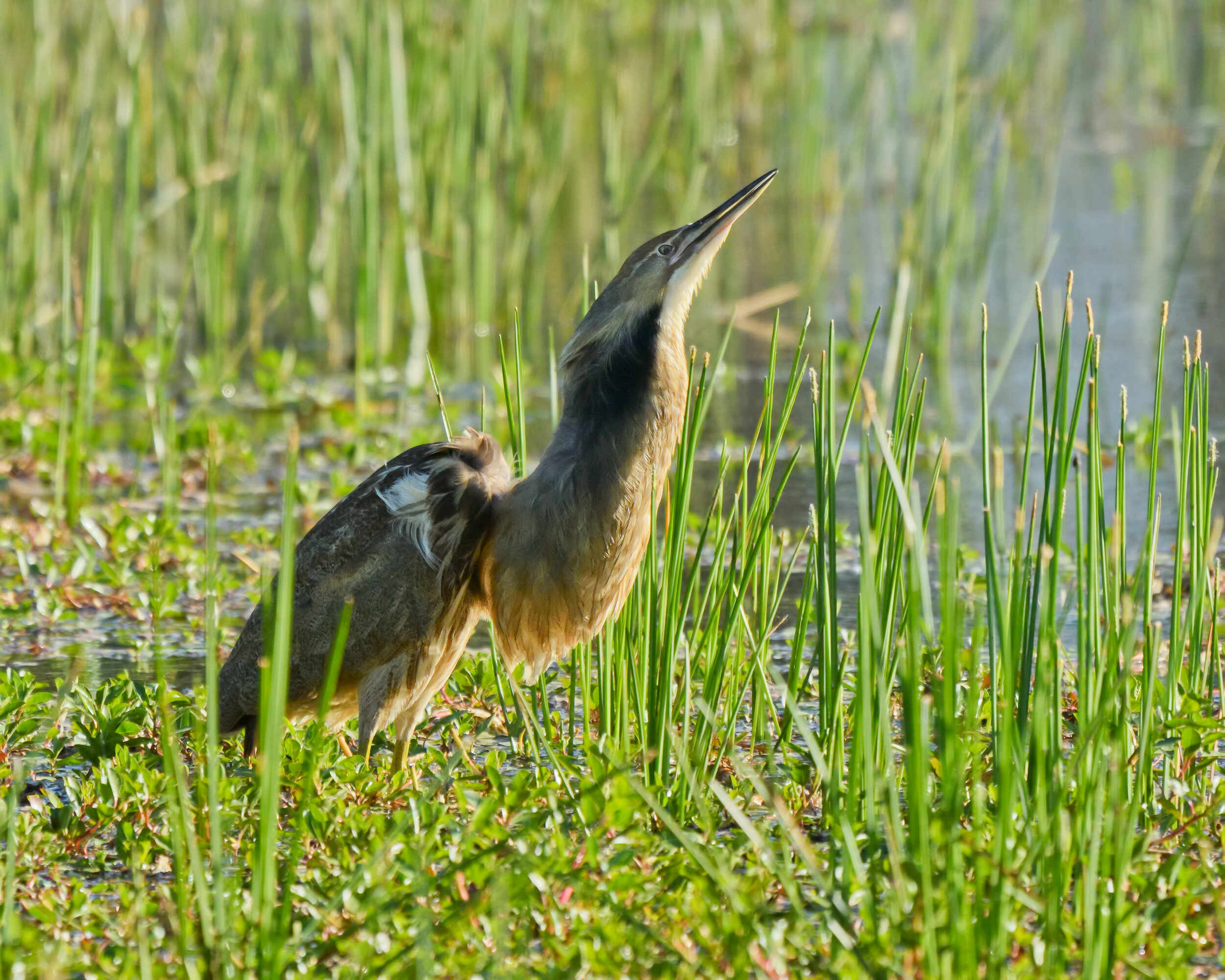
 Additional sites are detailed in Birding in Yolo County, CA by Steve Hampton.

The University of California, Davis Arboretum, in addition to other large trees on the U.C. campus, has produced excellent rarities (notably Scissor-tailed Flycatcher and Red Crossbills) and often provides good birding. There are nice remnant oaks on the highly altered remains of the Putah Creek channel that runs through campus, in addition to plants representing many different regions. Conifers on campus often harbor Red-breasted Nuthatches (fall through early spring). Chestnut-backed Chickadees (winter) are sometimes found in the pines and oaks along the arboretum trails. There has been a rookery of Black-crowned Night-Herons, Snowy Egrets, and Cattle Egrets at the western portion of the arboretum. The arboretum setting is very nice, but is somewhat marred by the loud roar of traffic. This is also an Accessible Birding Location. To learn more about the accessibility of this location visit our Accessible Birding page. eBird Sightings

From Interstate 80, about 14 miles west of Sacramento, take the U.C. Davis exit (exit 71) and turn right. It currently costs $6 to park in the lots along Old Davis Road and elsewhere on campus. From Old Davis Road, walk north to the trails that parallel the old creek channel. You may be able to find parking along the street at the western end of the arboretum. From Old Davis Road, turn left at California Avenue, and left at La Rue Road. After 0.4 mile, turn left on Garrod Drive and park near the gazebo.

Putah Creek Riparian Preserve is west of the main U.C. Davis campus and provides access to additional riparian habitat. It is usually more peaceful than the arboretum. Take Highway 113 north from Interstate 80 (about 14.5 miles west of Sacramento). Exit on Hutchinson Drive after 1.2 miles. Turn left, and go 1.3 miles on Hutchinson Drive before turning left on Hopkins Road. At the end of Hopkins Road in one mile, head left and park at the picnic grounds. Another access is from Pedrick Rd. Exit Interstate 80 at Pedrick Rd (17.5 miles west of Sacramento), go north for 2.6 miles and turn left into gravel lot after crossing Putah Creek. Walk under the bridge and continue downstream where many migrants and rarities have been found. eBird Sightings

Slide Hill Park has produced numerous interesting finds, including Mountain Chickadee, Cassin’s Finch, Red Crossbill, and Evening Grosbeak. Take the Mace Boulevard exit from Interstate 80 (ten miles west of Sacramento). Head north on Mace Boulevard (which will become East Covell Boulevard) for 1.8 miles and turn left on Monarch Lane. Turn right on Temple Drive in 0.1 mile and park in the lot or along the street. The trees in the surrounding neighborhood can be just as productive as those in the park. eBird Sightings

North Davis Ponds is a small area of wetlands and trees that can be covered fairly quickly. There is a boardwalk that provides access to different views of the wetlands. When conditions are right, shorebirds can allow very close study. It is a good place to look for Short-billed Dowitchers among the common Long-billed Dowitchers and Lesser Yellowlegs among the Greater Yellowlegs. A Ruff was once found here among the dowitchers. Take the Mace Boulevard exit from Interstate 80 (10 miles west of Sacramento). Head north on Mace Boulevard (which will become East Covell Boulevard), and in 3.5 miles, turn right on F Street. In 0.9 mile, turn left on Anderson Road and left into the parking lot. eBird Sightings

Long-billed Dowitcher, Image by Ray Rozema

Long-billed Dowitcher, Image by Ray Rozema

North Davis Farms is another very productive site. It can be excellent in migration. Take the Mace Boulevard exit from Interstate 80 (ten miles west of Sacramento). Head north on Mace Boulevard (which will become East Covell Boulevard), and in 4.2 miles, turn right on Anderson Road. In 0.6 mile, turn left on Falcon Avenue, then turn right on Goshawk Street and left on Kestrel Place. Park and walk past the end of the street, and cross the channel on the foot bridge. There are a lot of good trees to check, but you shouldn’t miss those along the pond to your right. Also walk west along North Davis Farms Road to check the other pond. You can turn right on Northfield Court and walk to the end. Currently, birders check the trees on the north side of the vacant lot, but access there may change. eBird Sightings

Willowbank Ditch is another small park gem that often provides excellent birding, especially in migration. Take the Mace Boulevard exit from Interstate 80 (ten miles west of Sacramento). Turn left over the freeway, and head south for 1.0 mile on Mace Boulevard. Turn right onto Montgomery Avenue, then, in 0.2 mile, turn right on Rosario Street. Park near the end of Rosario Street, and walk the bridge that crosses the Putah Creek channel. A Pacific Wren is sometimes here in winter. The trail goes in both directions along the nice stand of trees, but is generally more productive to the west. eBird Sightings

Chris Conard

Davis Wastewater Treatment Plant

Wilson’s Phalarope, Image by Daniel Brown

Wilson’s Phalarope, Image by Daniel Lee Brown

These are typical sewage ponds with numerous settling ponds and levees between them. During weekday business hours, the gates are open, and birders are welcome to walk the roads around the ponds, although to do this, you must check in at the office and sign a “Contractor and Visitor Orientation Sheet”. Weekend access is available with advance arrangement. Overland flow access is limited to plant staff only due to increased risk of contact with wastewater and emergency evacuation complexity.

Staying on designated roads will ensure that birders continue to be welcome at this facility.

Birding the site: Before reaching the treatment plant office, three large oxidation or settling ponds on the north side of the entrance road can be scoped from the road. The ponds support large numbers of wintering and migrating waterfowl: Northern Pintails, American Wigeons, Northern Shovelers, Lesser Scaup, and Ruddy Ducks, with occasional Ring-necked Ducks. There also may be large numbers of Wilson’s  Phalaropes (with smaller numbers of Red-necked Phalaropes), Long-billed Curlews, and Black-bellied Plovers. Occasional Pacific Golden-Plovers have been seen on the dikes between the ponds. Western Gulls have been seen in winter and Franklin’s Gulls are possible in summer.

The northeast pond contains duckweed (Lemna) and hosts a wide variety of waterbirds, shorebirds and passerines that use its many crisscrossed cells. Blue Grosbeaks nest in the trees between the ponds and the overland flow area to the east. Northern Harriers, American Bittern, Cinnamon Teal, and Gadwalls nest there. The overland flow may be viewed from the Davis Wetlands access road.

In the summer, during migration, there are often large numbers of swallows including Barn, Cliff, Tree, Bank, and Northern Rough-winged Swallows on the wires along the entrance road. eBird Sightings

Directions: From the intersection of Interstate 5 and Hwy 50 in Sacramento, drive west on Hwy 50 for 3.4 miles to where Interstate 80 merges with Hwy 50. Continue west on Interstate 80 for about 4.0 miles across the Yolo Causeway and exit at East Chiles Road/Road 32A (exit 78). At the stop sign, turn left. In 1.9 miles, veer right, cross the railroad tracks, and go north (the road becomes Road 105) until it dead ends at Road 28H. Turn right onto Road 28H, the levee road which leads to the Control Plant building. The plant is open weekdays from 7:00 a.m. to about 3:30 p.m. and most weekends until 1 p.m. As mentioned above, to walk around the ponds rather than scoping from the entrance road, birders must first check in at the Control Plant office.

Maureen Geiger and Joan Humphrey


City of Davis Wetlands

Bonaparte’s Gull is occasionally found at the City of Davis Wetlands. Image by Daniel Brown

Bonaparte’s Gull is occasionally found at the City of Davis Wetlands. Image by Daniel Lee Brown

This evolving wetland consists of 400 acres of ponds and upland habitat of varying depths and is a continuation of Davis’s storm water and wastewater treatment process.

Birding the site: In general, the wetlands produce shorebirds, waterfowl, Northern Harriers, Marsh Wrens, Common Gallinules, and a variety of swallows. Yellow-headed Blackbirds have bred on Tracts 6 and 7. Presence and variety of birds depends on water depth and season.

The Wetlands are divided into the larger Stormwater and Wastewater Lagoons and seven smaller tracts. When water levels are low in Wastewater Lagoon, check the exposed spits of land for American White Pelicans, Double-crested Cormorants, White-faced Ibis, and gulls and terns, including occasional Bonaparte’s Gulls. Clark’s Grebes, Western Grebes, Eared Grebes, American Avocets, Black-necked Stilts, diving ducks, including occasional Redheads, are also found in this lagoon. Cinnamon Teal occur in large numbers, and Ruddy Ducks and Gadwalls are present year round. Green-winged and occasional Blue-winged Teal can be found except during mid-summer months.

Numbers and intensity of birds on Stormwater Lagoon varies depending on the amount of water present. As this water evaporates in the summer months, large numbers of migrating shorebirds such as Long-billed Dowitchers and both Greater and Lesser Yellowlegs can be found. Peregrine Falcons may be attracted by the shorebird activity. In winter, waterfowl abound.

On leaving the Wastewater Treatment Plant or the Davis Wetlands, checking the ditch and fence along Road 28H may produce Burrowing Owls; also check the ponds north of the road which may harbor large numbers of ducks and shorebirds. eBird Sightings

Directions: Follow the directions above to reach the Davis Wastewater Treatment Plant and continue east past the Control Plant building. Stop at the access gate and sign in at the wooden kiosk to the left of the gate. The gate is kept closed by a bungee cord; be sure to close this behind you, and sign out when you leave. Vehicles must remain on the tour loop, but pedestrians are welcome to walk the other roads in the wetlands. Tours are generally offered by the Yolo Basin Foundation on the first Saturday of the month.

The Wetlands are only open to the public during limited times during the year. From February 15th through August 31st, the wetlands are open seven days/week from 7 a.m. to 1 p.m. From September 1st through February 15th, the wetlands are open Mondays only from 7 a.m. to 1 p.m. For updated access information to the wetlands, check the City of Davis website.

Maureen Geiger and Joan Humphrey


Yolo Egret and Heron Rookery

Black-crowned Night-Herons, Image by Chris Conard

Black-crowned Night-Heron, Image by Chris Conard

This rookery is very active in spring with Great Egrets, Snowy Egrets, Cattle Egrets, Black-crowned Night-Herons, and occasionally Great Blue Herons nesting in a large stand of eucalyptus trees on private land.

Birding the site: The time to visit is from May into July (March and April for courting and nest building). About a quarter of a mile after turning onto Road 103, check the large stock pond on the left for nesting Gadwalls, Black-necked Stilts, Canada Geese, and Burrowing Owls on the island. Also check the surrounding fields and overhead for Swainson’s Hawks and along the overhead wires and fences for Loggerhead Shrikes, Blue Grosbeaks, and Western Kingbirds.

When you reach the rookery, the cacophony of bird squawks, quorks and cries will announce the birds before you leave your vehicle. Many egrets and herons can be seen flying to and from the rookery in all directions, and young in the nest (and occasionally on the ground) may be found in a variety of ages from just hatched to ready to leave the nest. In recent years, most of the trees have been thinned out, reducing available nest sites somewhat. eBird Sightings

Directions: From the intersection of Interstate 5 and Hwy 50 in Sacramento, drive west on Hwy 50 for 3.4 miles to where Interstate 80 merges with Hwy 50. Continue west on Interstate 80 for about 4.0 miles across the Yolo Causeway and exit at East Chiles Road/Road 32A (exit 78). At the stop sign, turn left. In 1.9 miles, veer right, cross the railroad tracks, and go north (the road becomes Road 105) until it dead ends at Road 28H. Turn left on Road 28H, drive past the Yolo County Landfill, then turn right onto Road 103. The rookery is in a large tract of eucalyptus trees about 0.8 of a mile from Road 28H. This is a narrow, rural road, often traveled by large, wide farm machinery, so pull well off the road to park on the shoulder.

Maureen Geiger


Woodland Water Pollution Control Facility

Semipalmated Sandpiper, Image by Daniel Brown

Semipalmated Sandpiper, Image by Daniel Lee Brown

The treatment ponds have a fine history of attracting good shorebirds, gulls, and waterfowl. The peak season for finding rare shorebirds is from July through September, depending on water levels. Good numbers of shorebirds and gulls can be found in the winter, and spring migration (April and early May) can be productive as well. A scope is very helpful.

The species list is similar to that found at the Davis Wetlands, though Pacific Golden-Plovers (fall, winter) are more regular here. Semipalmated Sandpipers (July, August), and Baird’s Sandpipers (August, September) are present every year in very low numbers. Rarities have included American Golden-Plover, Red Knot, and Sanderling. Look for Black Terns in the first week of May. eBird Sightings

Note: The plant is only open Monday through Friday, 7:30 a.m. to 3:30 p.m. It is closed on weekends and holidays. Park at the “birder parking area” and sign in. There is access information on the inside lid of the sign-in box. Do not go to the plant office or bird from the paved road. Access here was carefully arranged by Yolo Audubon, so please be respectful of the plant’s rules and staff.

Directions: From Sacramento, take Interstate 5 northeast (17.4 miles north from Highway 50) to the Road 102 exit in Woodland. Head left, over the freeway, for 0.9 mile and turn left into the treatment plant entrance at Road 24, opposite Gibson Road. Birder parking is on the right in 0.5 mile. Sign in and walk around the treatment ponds. At times, the closest ponds have the best conditions, while at others you will need to walk up to a half-mile to find the ponds with the best conditions and concentration of shorebirds.

From Davis, take the Mace Boulevard exit from Interstate 80 (ten miles west of Sacramento). Head north on Mace Boulevard (which will become East Covell Boulevard), and turn right on Pole Line Road after 2.7 miles. Continue for 6.9 miles (Pole Line Road becomes Road 102) to Road 24 (opposite Gibson Road) and the plant entrance, and turn right (see above).

Chris Conard


Dunnigan Hills

Northern Harrier, Image by Daniel Brown

Northern Harrier, Image by Daniel Lee Brown

This area of beautiful rolling hills lies west of Interstate 5 north of Woodland, crosses I-505 (which runs from Vacaville to Dunnigan), and extends toward the Coast Range to the west. Dotted with cattle and sheep ranches as well as vineyards, field crops and hunting clubs, these hills serve as temporary home to many species of birds in the winter, particularly raptors. Recent orchard expansion has fragmented some of the sites mentioned below.

Birding the site: This entire expanse of numbered roads in these agricultural lands is a winter haven for raptors such as Golden Eagle, Northern Harrier, Ferruginous Hawk, Red-tailed Hawk, Rough-legged Hawk (which is irruptive, i.e., common some years & nearly absent in others), American Kestrel, Merlin, and Prairie Falcon. Burrowing Owls are often found east of the 505 freeway along Roads 16, 90B, 15B, and in the first half-mile of 92B north of 15B. The acres of vineyards harbor occasional Greater Roadrunners (especially along Road 16, west of the 505 freeway, and the first half-mile of 92B north of 15B). Ring-necked Pheasants are common.

Another reason to visit this area during winter is the presence of large flocks of Horned Larks which may include several of the Longspur species, particularly Chestnut-collared, with the potential for Lapland and Thick-billed. These large flocks may be found throughout this region. During late fall and early winter, the larks may be found foraging in the large, open expanses of low vegetation. Mountain Plovers have also been found in this area. Generally, by mid-February, the vegetation has reached a height that blocks views of any small birds on the ground. Mountain Bluebirds are regularly found in the area as well, especially to the west of the 505 freeway.

In addition to the attraction of birds, several sheep ranches in this area use Kuvasz dogs to guard their sheep. These large, beautiful white dogs were originally bred in Hungary and trained to live with and guard flocks of sheep. They may occasionally be seen along Road 92B, which can be reached by turning south from Road 13/E10, 0.9 mile west of Interstate 5. This narrow road winds along the Willow Spring Creek through the hills which are dotted with sheep (after 3.2 miles, it reaches Road 15B). There are several small marshes along Road 92B, and this is an especially good area to watch for raptors. eBird Sightings

Directions: From Sacramento, take Interstate 5 north (for about 29 miles) past Woodland to the Zamora Exit (exit 548). Turn left, cross over the freeway, and drive west on Road 13/E10. This road (which trends southwest and becomes Road 14) reaches the 505 freeway in 2.2 miles, and continues on a couple miles until it dead ends at Road 85. On the west side of I-505, heading south on the frontage road (Road 90A) will lead to Road 16 in 1.9 miles. The entire area is crisscrossed by numbered roads, providing many options for wandering the area, all of which can produce interesting birds.

Maureen Geiger


Rayhouse Road

Bell’s Sparrow, Image by Daniel Brown In 2013, the Sage Sparrow was split into two distinct species: Bell’s Sparrow and Sagebrush Sparrow.

Bell’s Sparrow, Image by Daniel Lee Brown

The Blue Ridge area of Yolo County is a rugged mix of steep mountains, oak woodlands, patches of riparian, outstanding vistas, and a sea of chaparral. Early mornings in the spring are best, with opportunities for Common Poorwill and bobcats in the road in the predawn, as well as Mountain Quail (calling—hard to see), California Thrasher, Bell’s Sparrow, and Lawrence’s Goldfinch. The lower, more heavily forested portions of the road have produced numerous records of Pileated Woodpeckers. Band-tailed Pigeons have also been found here.

Although the road has been closed for some time, you can park in the lot just off Hwy. 16 and walk down into the Canyon. After crossing the bridge, the road starts to climb and although some sections can be steep, there are many miles of roads and trails to explore. Walking just the first mile can be productive.

Birding the site: As with the rest of life, you can’t be everywhere at once. If your targets are the chaparral birds, then heading quickly through the lower sections of road is probably your best bet. Early mornings are best for singing birds everywhere, but this is especially so with California Thrashers, Bell’s Sparrows, and Black-chinned Sparrows (very rare). Once the wind picks up or it gets warm, your chances of finding many of these birds drop precipitously. The expanse of the area and all it has to offer will probably draw you back for multiple trips. Exploring the oak woodlands and riparian habitat also has its rewards.

The low water bridge (not passable when the creek is running high) on Cache Creek often has Cliff Swallow nests, allowing for close views. American Dippers have been found here on rare occasions. Canyon Wrens can be found in the lower section of Rayhouse Road—most often from Cache Creek up a short distance to the barn on the right side of the road.

After crossing the low water bridge and climbing out of the creek channel, there is a gated road on your left and signs to the Blue Ridge Trail. There is nice woodland habitat to explore. The trail itself is extremely steep (a 2,100- foot climb in four miles, and most of the climb in just two miles!), but even a short excursion is worthwhile, and it doesn’t get really steep immediately.

Back to Rayhouse Road: after passing some riparian habitat and oak woodland, the road climbs rather steeply. It is oak woodland for the first 3.3 miles from Highway 16, then it transitions to chaparral. The woodlands can be alive with migrants in season and have produced many Pileated Woodpecker reports. As you stop along the road, you may hear the “quark” of Mountain Quail, but you will be lucky to see one. When you reach the chaparral, look and listen for Blue-gray Gnatcatchers, California Thrashers, and Bell’s Sparrows. If you are very lucky, you might hear a Black-chinned Sparrow. Lazuli Buntings can be numerous. At 4.8 miles from Highway 16, turn left for 0.6 mile to Fiske Lake. This has been the most regular site for Lawrence’s Goldfinches. Back to Rayhouse Road, and another three miles will take you to Davis Creek Reservoir, where Bald Eagles have nested.

eBird Sightings - Site 1, Site 2

Directions: From downtown Sacramento, take Interstate 5 north for 21 miles, through Woodland, to the Esparto/Highway 16 exit (exit 541). Go west for 2.9 miles and make a right toward Esparto and the Capay Valley on Highway 16. Follow Highway 16 for 38 miles to Yolo County Road 40 and turn left. This is 5.1 miles past the small Capay Valley town of Rumsey. Park in the lot for the Lower site of the Cache Creek Canyon Regional Park. Follow the track northeasterly that parallels the highway for 0.2 mi where the track turns right to cross Cache Creek. The low water concrete bridge is passable only when flows are moderate. Be forewarned that flows can be increased due to increased dam releases during your birding time. If the gate is closed but it is safe to walk across the bridge, there are many miles of roads and trails to explore on foot.

Chris Conard

For additional information, check Birding in Yolo County, CA by Steve Hampton.

Also check: www.yolocounty.org