Originally published October 25, 2022
Suggested Birding Sites for November
Lincoln WWTP and Placer County Roads
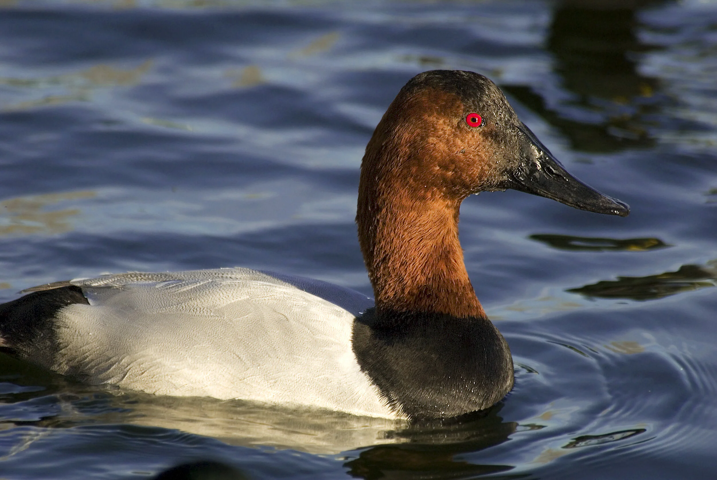
Canvasback were reported in November 2020 at the Lincoln WWTP, Image by Daniel Lee Brown
Start by birding the Lincoln water treatment plant. There are several large ponds which can hold a variety of ducks. Be sure to check in at the WWTP office when you arrive, especially if you haven’t birded there in a few years. The folks at the treatment plant are happy to let birders visit, but the access to the plant has changed in the past few years. From the plant, you can drive nearby backroads of Placer County, searching flooded fields for wintering waterfowl and shorebirds. Several open dry fields may provide hunting grounds for raptors.
Directions
Take I-80 east from Sacramento to Roseville. Take Hwy. 65 west to Sunset Boulevard; take West Sunset Boulevard, then right on North Foothills Boulevard. Turn left on Athens and right on Fiddyment Road to 1245 on the right.
Address for Lincoln WWTP: 1245 Fiddyment Rd, Lincoln, CA 95648
Please note hours are 7am to 3:30pm weekdays only, and birders must sign in and out at the office.
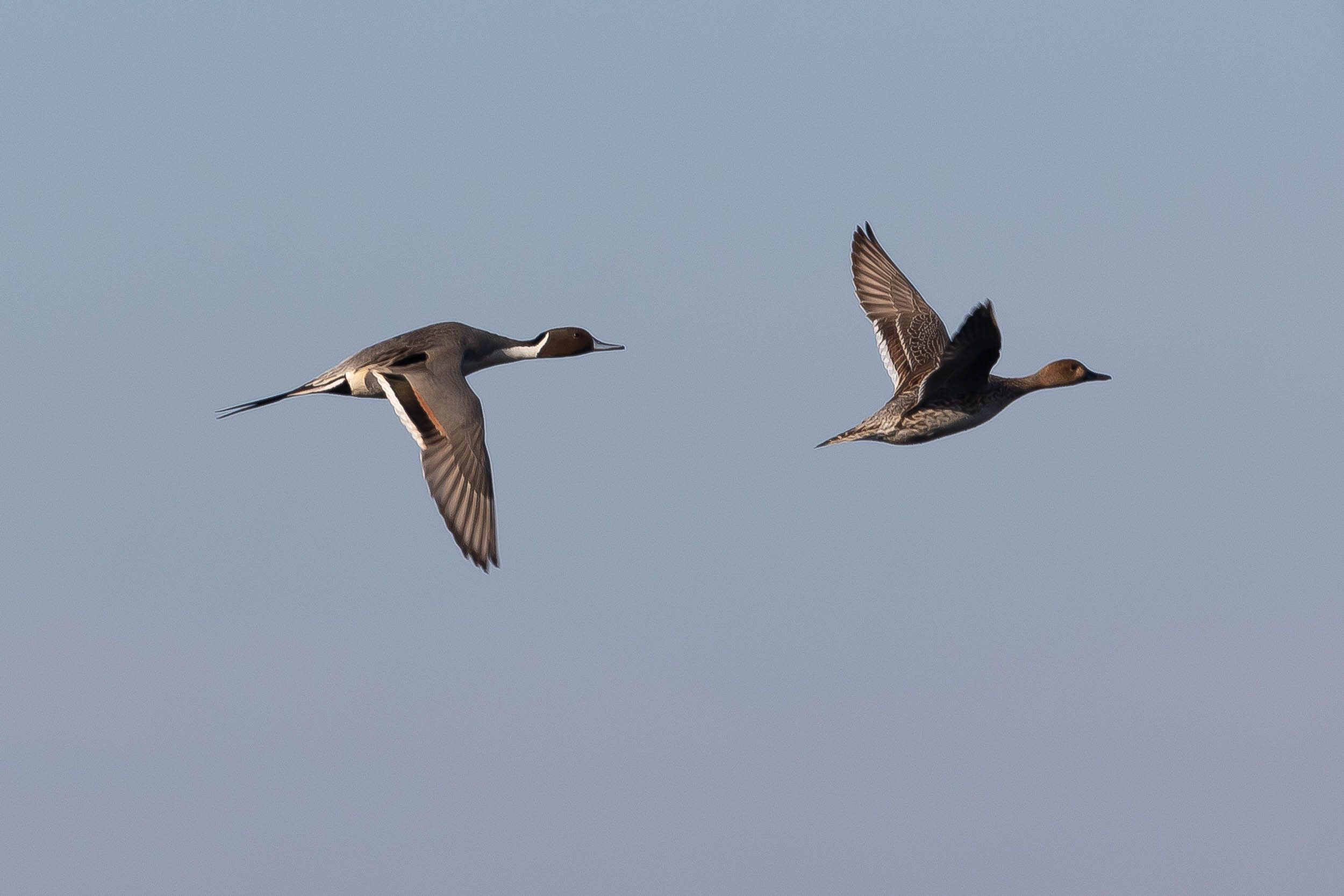
Northern Pintail are commonly found at Cosumnes River Preserve in the fall and winter,
Image by Larry Hickey
Walking the boardwalk loop is a great way to check out the wintering waterfowl, including a variety of duck species, Greater White-fronted Geese, and Sandhill Cranes. Dowitchers, Wilson’s Snipe, and yellowlegs should be present. There are always some passerines and raptors. Driving Desmond and Bruceville Roads can also be good viewing areas. Visit the Cosumnes River Preserve Website for more information including a digital trail map.
Directions
To reach the visitor center, take Interstate 5 about 20 miles south from Sacramento until you reach Twin Cities Road exit. Go east on Twin Cities Road for one mile to Franklin Boulevard. At the stop sign, go south for 1.7 miles, and the visitor center will be on your left.
Address: 13501 Franklin Blvd, Galt, CA 95632
Cosumnes River Preserve is an Accessible Birding location. To learn more about the accessibility of this location click here.
Solano Lake/Putah Creek
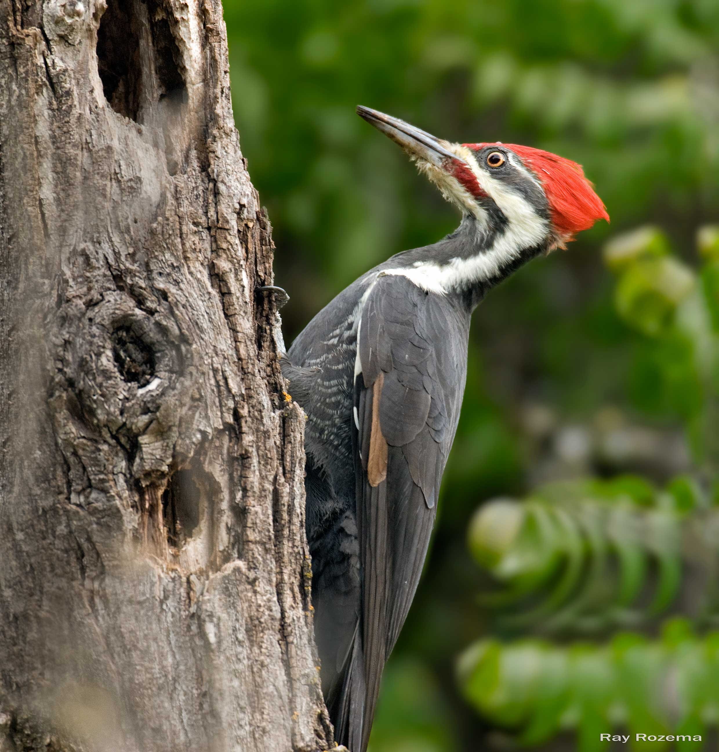
Pileated Woodpecker, Image by Ray Rozema
Putah Creek is home to many resident and wintering birds. Nearby Lake Solano is a good area for wintering ducks including possible Barrow’s Goldeneye and Hooded Mergansers. Phainopeplas and Brown Creepers are possible, and Pileated Woodpeckers have been found in the area.
Directions
To get to Putah Creek, take I-80 to the Pedrick Road exit between Davis and Dixon. Head north on Pedrick Road After a mile or two, there is a bridge over the creek and the parking lot is on the left. To get to Lake Solano from Putah Creek, head further north on Pedrick Road and turn left on Russell Blvd. Continue west on Russell Blvd. past the town of Winters and follow the signs to Lake Solano Park.
Address Lake Solano Park: 8685 Pleasants Valley Rd, Winters, CA 95694
Parking & Fees: There is a $6 fee per car at Lake Solano Park.
It is also worth heading slightly further up Highway 128 to Monticello Dam, where Canyon Wrens and Rufous Crowned Sparrows are sometimes found.
Salt Springs Valley
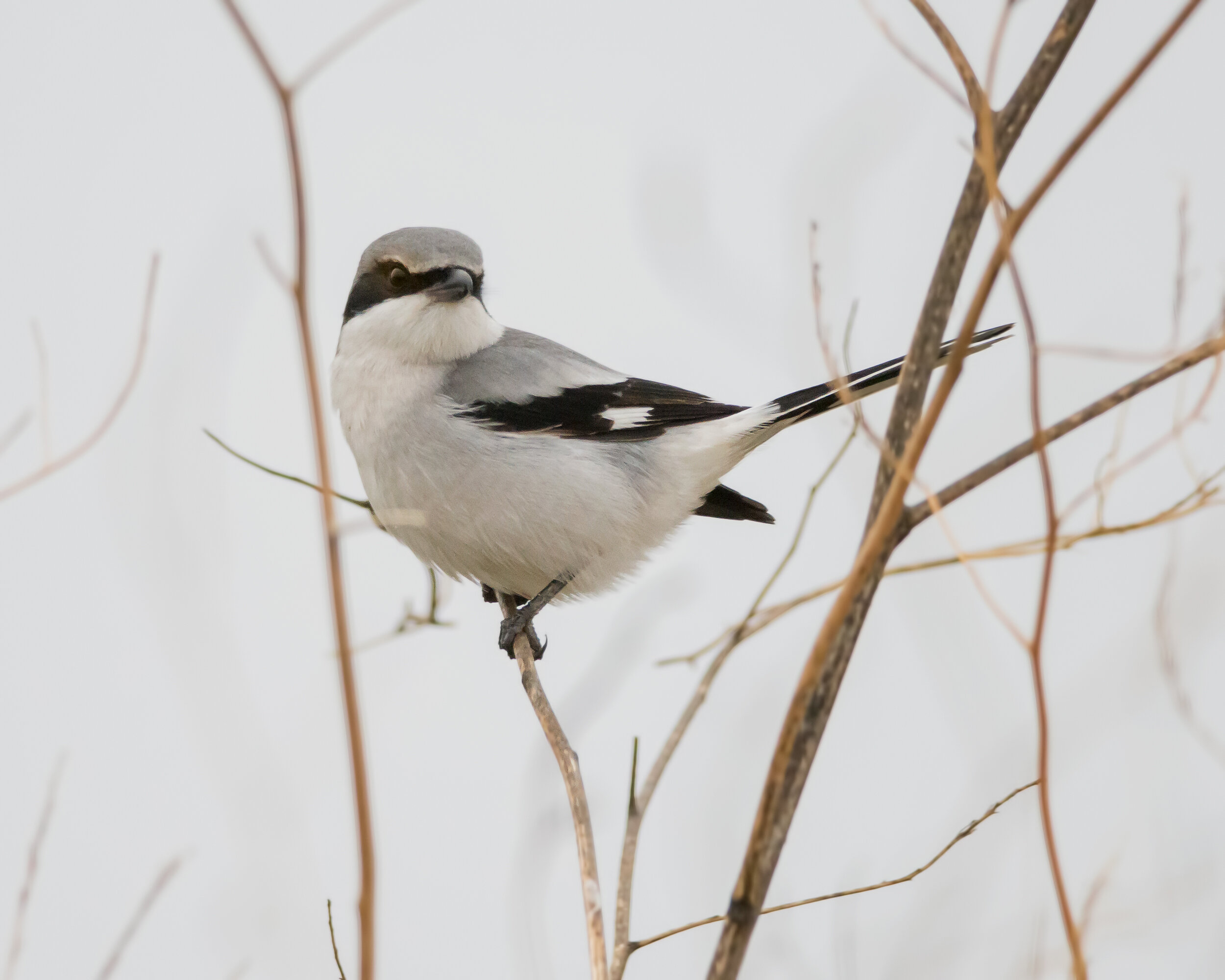
Loggerhead Shrike have been reported in this area, Image by Daniel Lee Brown
This area is located in western Calaveras County about an hour and a half drive
from Sacramento. The open valley and its lake are home to many wintering ducks, hawks, eagles, owls and grassland birds.
Hunt Road, Rock Creek Road and Salt Springs Valley Road form a loop around the lake and have plenty of places to pull off the road to look at the birds. Be prepared for cold, windy conditions and thick fog. This is an extremely rural area, and though gas stations, restrooms, and dining establishments can be found in Valley Springs and Copperopolis, there are none in the valley itself.
Directions
To get there from Sacramento, take Highway 99 south to Highway 12 in the town of Lodi. Highway 12 intersects Highway 26 in the town of Valley Springs. Take Highway 26 south to Jenny Lind Rd. Jenny Lind Road becomes Milton Road which then intersects Hunt Road and Rock Creek Road.
Google Directions for Salt Springs Valley Reservoir
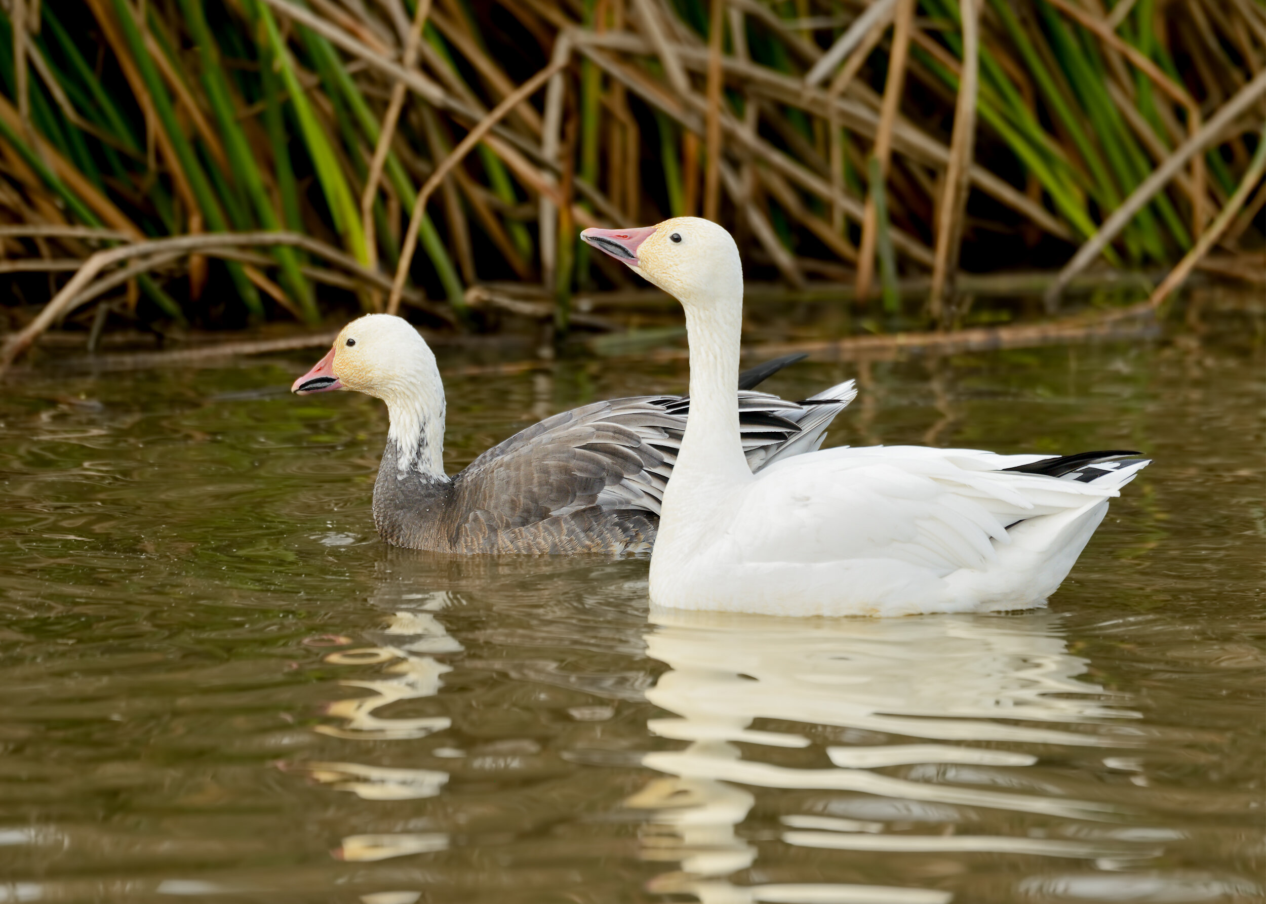
Snow Goose, Image by Daniel Lee Brown
This refuge is a prime wintering area for migrating ducks and geese with both walking trails and an auto route. Expect to find Snow, Ross, and Greater White-fronted Geese, along with Northern Pintail, Northern Shoveler, American Wigeon, Green-winged Teal, Gadwall and Bufflehead. Rarer but still frequently sighting visitors include European Wigeons, Blue-winged Teal, Ring-necked and Ruddy Ducks. Raptors such as Peregrine Falcon and Bald Eagles are also frequently sighted. At the California Department of Fish and Wildlife website, you’ll find maps of the wildlife viewing area, a handy bird checklist and more.
Directions
From Sacramento, take Interstate 5 for 7 miles north of Highway 50. Take the Highway 99/Highway 70 exit (exit 525B) toward Marysville/Yuba City. After 12.5 miles, at the 99/70 split, take Highway 99 toward Yuba City—do not take Highway 70. Stay on Highway 99 for another 32 miles, heading through Yuba City to Like Oak. At Live Oak, turn left on Pennington Road. Pennington Road will make several turns and bends trending north/northwest after 5.9 miles, where it becomes Powell Road for 0.5 mile, then bears left to become North Butte Road for 1.8 miles. After about eight miles from Highway 99, turn right on Almond Orchard Avenue. From here, it is 1.7 miles to Rutherford Road. Turn left (west) on Rutherford Road into the Gray Lodge Wildlife Area.
Address: 3207 Rutherford Rd, Gridley, CA 95948
Parking & Fees: There is a $4.50 per person charge at Gray Lodge; so it’s wise to bring the exact amount for the Iron Ranger.
Gray Lodge Wildlife Refuge is an Accessible Birding location. To learn more about the accessibility of this location click here.
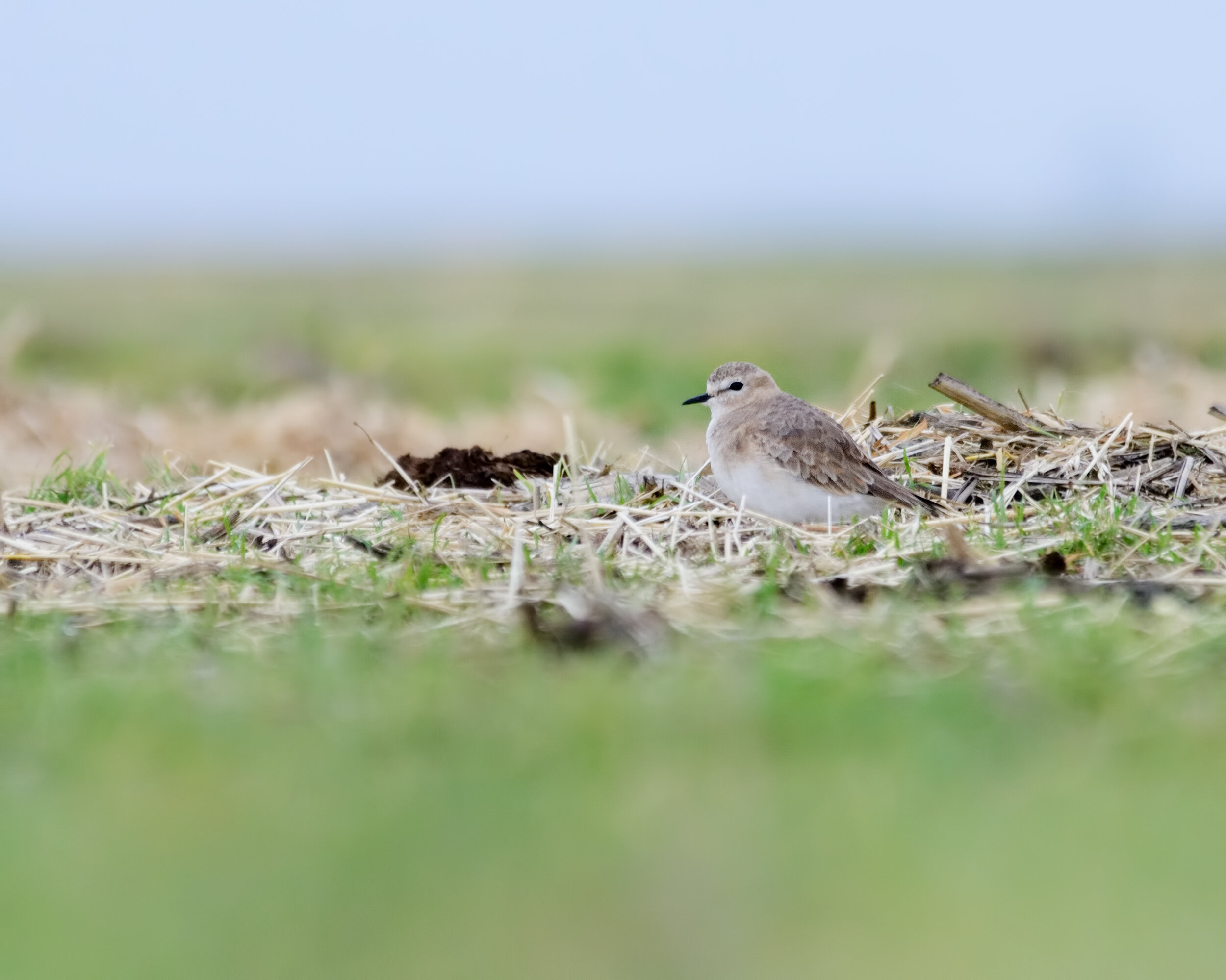
Mountain Plover, Image by Daniel Lee Brown
This is a great area for wintering raptors such as Ferruginous Hawks and Golden Eagles as well as Loggerhead Shrikes, Say’s Phoebes and with luck, Mountain Plovers and Tricolored Blackbirds. Traffic is sparse on these rural roads which helps make birding pleasant and rewarding. Be sure and explore the side roads off of Robinson Road such as Creed Road, Goosehaven Road, Flannery Road and McCormack Road. After crossing Hwy. 12 take Birds Landing Road to Shiloh where there are more possibilities for good birding.
Directions:
Take I-80 from Sacramento west about 19 miles and take the Hwy. 113 exit heading south. Go through Dixon and at 17 miles turn left on Robinson Road. You can drive this road and explore side roads such as Creed Road, Goosehaven Road, Flannery Road and McCormack Road. You can continue south across Hwy. 12 and take Birds Landing Road to Shiloh.
Latitude/Longitude for Robinson Road: 38.2199083,-121.7823315

Rofous-crowned Sparrow, Image by Ray Rozema
This area is located in the Auburn State Recreation Area at the confluence of the North and South Forks of the American River. Wrentits, Rufous-Crowned Sparrows, and other species typical of the Sierra Foothills are often seen here. Bald Eagles, Peregrine Falcons, Band-Tailed Pigeons, and even Canyon Wrens are possible as well. The first 2 miles of the trail are fairly flat and follow along the American River. The trail then starts to head uphill and continues for another 5 miles or so.
Directions:
To get there from Sacramento, take I-80 east to the town of Auburn. Take the exit for Highway 49 south towards Placerville. Once you cross the American River into El Dorado County, the parking lot for the trailhead is on the left side of Highway 49 and is fairly well marked.
Google Directions for Quarry Trail Parking Area

Tundra Swans, Image by Daniel Lee Brown
This great area is only 10 minutes from downtown Sacramento. The area has walking trails and an auto route. Depending on the extent of flooded fields on the auto tour route, there may be good numbers of shorebirds and waterfowl. This can also be a good viewing area for migrating swans.
Directions
Take Interstate 80 west across the Yolo Causeway (about 6.5 miles from Sacramento) and exit at East Chiles Road/Road 32A (exit 78) at the west end of the causeway. Turn right at the stop sign and pass under the freeway. Immediately turn left, drive up onto the levee, then drop down into the wildlife area. The auto loop is posted along the way.
See updated maps & information on the Yolo Basin Foundation website.